Flood risk management annual report 2023 to 2024
Foreword
This Annual Report summarises the range of activities undertaken by Natural Resources Wales in managing the risks from flooding in Wales, in 2023/24.
It is clear that we operate in very challenging times. The period October 2023-March 2024 was the second wettest winter ever in the UK, according to the Met Office (Climate change drives increase in storm rainfall - Met Office). There were 10 named storms, and the Met Office analysis shows that there was 20% more rainfall, and that rainfall was 15% more intense, due to climate change. These are both sobering statistics – the climate experts can demonstrate and evidence that we are experiencing more rainfall, and more intense rainfall, due to climate change.
So, the evidence is clear that we are seeing the impacts of a changing climate. We are also experiencing extreme pressures on our natural world, and a nature emergency. It is clear that we need to decarbonize to prevent more climate and nature impacts, but that much of the impacts are now locked in. The twin needs for adaptation to climate change and building resilience to the impacts of climate change, plus enhancing nature as we do it, are not for the future, but are with us now.
We recognise this need at NRW. Whilst we have good flood risk management practices in place – and many examples are given in this report – we cannot be complacent. We need to continually adapt and improve our thinking and our practices. This is very challenging though, in a world where there are competing demands on public sector priorities and resources. It is important that there is sustained investment in the sector from Governments, or we will not be able to respond in the ways we know we must and to the extents we know we need. In this last year, we published our Long Term Investment Requirements report which assesses the investment needed in flood defences under various scenarios. We know that flood defences alone will not provide resilience to flooding, but they are an important part of the picture, and the needs are considerable. We hope to provide investment requirements for other areas of flood risk management in the future, to build up the complete picture.
In responding to the near term needs, we also published our Flood Risk Management Plan for Wales during 2023/24. This specifies the actions we plan to take over the next 6 years, to manage the here and now flood risks in Wales, and to prepare for the future.
This Annual Report gives a snapshot of the areas we are working on, both for the short and for the longer term, as we work across the full range of flood risk management interventions to help lower the risks to the people and infrastructure of Wales. There is a lot to do, and it will take the collective efforts of all partner organisations and communities to deliver. I hope this report, in showcasing the good work being done across NRW, will help motivate and inspire both those who work in the sector now, and those who want to become involved. This is important work, that can really make a difference to lives and livelihoods, the sustainability of our country and its environment, and the well-being of future generations.
Jeremy Parr
Head of Flood and Incident Risk Management
Natural Resources Wales
Executive summary
Natural Resources Wales (NRW) is the largest Welsh Government Sponsored Body, and we have as our core purpose the sustainable management of natural resources in Wales.
We have a range of roles and responsibilities, ranging from regulator to advisor, landowner and operator and emergency responder. We have a strategic oversight role for flood and coastal erosion risk management which involves the general supervision and communication of flood and coastal erosion risk management in Wales. We also have powers to manage flooding from main rivers, reservoirs, and the sea.
In Wales, there are estimated to be 272,817 properties at risk of flooding. This is approximately 1 in 7 properties in Wales. We take a risk-based approach to managing the risk of flooding through the activities we do. This report summarises the investment, key activities, and achievements in managing flood and coastal erosion risks across Wales by NRW for the financial year from April 2023 to March 2024. It is based on the best available information at the time of writing (Spring 2024).
We intend to use this annual report to form part of the statutory report that we have a duty to undertake (under Section 18 of the Floods and Water Management Act) on progress of the implementation of Welsh Government’s Flood and Coastal Erosion Risk Management Strategy. The Strategy was published in October 2020, and many of the activities described in this annual report will contribute toward the delivery of the objectives and measures included within that Strategy.
Some of key highlights from 2023/24 include:
- Investment of £56.6m of Welsh Government funding on key flood risk management activities.
- The completion of a significant flood alleviation scheme in Ammanford (Carmarthenshire) that protects 223 properties. We also made progress on major schemes at locations across Wales such as Stephenson Street (Newport), Pwllheli and Porthmadog (Gwynedd) and Cardigan (Ceredigion).
- A further 824 properties directly benefitted from the ongoing sustained level of flood protection provided by our capital maintenance work.
- Publication of our Flood Risk Management Plan (FRMP) which sets out our priorities for managing flood risk for the next six years.
- The delivery of measures from the Welsh Government Flood and Coastal Erosion Risk Management Strategy including publishing the Section 18 report on progress against the strategy and publishing our assessment of the long term investment requirements (LTIR) for managing our flood risk management assets in the future.
- Delivery of improvements to our prioritisation of our routine asset maintenance programmes through the introduction of an new risk based approach.
- Delivery of improvements to the flood forecasting service and the hydrometric network which lead to improvements to our flood warning service.
- Continued development of key ICT projects to replace our Flood Warning System and Telemetry system.
- Made significant progress on the development of our new and updated Flood Warning Service which will enter operation in the summer.
Further information on all of these highlights, plus other key achievements, is included in this report.
Introduction
This annual report details our key achievements and deliverables for flood and coastal erosion risk management for the financial year 2023/24. It provides detail on the activities that contribute towards the management of flood risk in Wales and also highlights key metrics and statistics which demonstrate the level of effort that goes into managing flood risk and the scale of the challenge faced.
This report does not cover every activity or service area in detail and is intended as a summary of the 2023/24 financial year highlights. The information and data presented in this report is based on data available at the time of producing this summary (spring 2024). This report is a recurring annual publication and will complement the delivery of the next progress report on the Welsh Government Flood and Coastal Erosion Risk Management Strategy (the ‘Section 18 report’, required under Section 18 of the Floods and Water Management Act).
Storms and flooding experienced over the past year (April 2023 – March 2024)
Each year, we plan the work we want to deliver to manage flood risk. On top of that, we must respond to flood events when they happen. Our response may be reactive to manage the flood event at the time, or it may generate additional work that we need to deliver. This section provides a summary of the more notable flooding and storm events during the year that we responded to, including those that caused significant disruption or damage to communities.
We monitor and respond to floods whenever they happen - 24 hours a day, 7 days a week, 365 days a year. This includes tracking forecasts, issuing warnings, ensuring flood and hydrometry assets are operating properly, posting up-to-date information on our website, handling media interviews and queries, supporting other incident responder organisations and fixing damage caused to defences after storms. When an event occurs it clearly impacts our ability to deliver other planned work as we react to the challenges each severe weather event introduces, both during and in the period following these events, as we deal with the impacts and the aftermath.
During the previous financial year (2022/23), there were no UK named storms. For the period from April 2023 to March 2024, there have been 12 named storms. Two were from the previous year that unusually impacted Wales in August 2023 and 10 were from the 2024 storm season. This has made winter 2023/24 wet and challenging with many days of elevated flood risk. There have been more flood alerts issued during 2023/24 than in any of the previous 3 years which indicates how consistently wet the winter period has been. Not all of the named storms have led to flooding impacts but the named storms and unnamed storms that did are described below.
Unnamed storm, 20 September 2023
The remnants of Hurricane Lee which caused impacts in Bermuda, the US and Canada bought high winds and bands of heavy rain that caused flooding of roads and disruption in Swansea, Carmarthenshire and Powys. At Clydach in the Tawe valley, the river Clydach peaked at 4.16m and led to flooding of the Mond Valley Golf club and the Vardre RFC pitches and buildings.
Storm Babet, 18 to 21 October 2023
Storm Babet was the third wettest independent 3-day period across the whole of England and Wales since 1891. Impacts were felt in communities across North and Mid Wales as the storm triggered 46 flood warnings of varying levels in a 48-hour period demonstrating the huge amount of rainfall that fell in this area of Wales over a relatively small period of time. Transport was affected as roads and railways were flooded and many schools were forced to close. In some areas properties were evacuated as a result of the heavy rain and rising floods which led to the flooding of approximately 160 properties in Conwy, Denbighshire, Flintshire, Wrexham and Powys. A severe flood warning meaning that there is a danger to life was issued for Llandrinio, Powys covering the area where the Severn and Vyrnwy rivers meet.
Storm Ciaran, 31 October to 1 November 2023
Storm Ciaran bought very strong winds and heavy rain soon after Storm Babet. The already saturated catchment of the River Ritec in Tenby meant a Severe Flood Warning was issued as the river reached record levels. We attended the multi-agency response and the advice we gave led to the safe and successful evacuation of over 900 people to safety as flood waters inundated the Kiln Park Holiday site in the area.
Storm Henk, 2 January 2024
Storm Henk was the 8th named storm of the season. It bought strong winds and heavy rain across Wales. Worst affected was the River Ritec in Tenby that was subject to a severe flood warning and flooding of the Kiln Park caravan park for the second time this winter. During Storm Henk we also issued a total of 30 Flood Warnings and 40 Flood Alerts across Wales. There was widespread disruption from the storm and although several rivers reached flood warning levels and many watercourses were out of bank, our network of flood defences prevented flooding in many areas.
Storm Isha, 21 to 22 January 2024
Storm Isha brought winds as strong as 90mph accompanied by some very wet weather that saw the high ground of North Wales receive 50mm of rainfall widely and in places, over 100mm. Roads were flooded in North Wales along with much disruption caused by the strong winds. The flood risk posed by Storm Isha was diminished due to arriving after a fortnight of cold and dry weather yet despite this, at the peak of the storm 6 Flood Warnings and 36 Flood Alerts were issued.
The period from October 2023 to March 2024 was the second wettest winter ever in the UK, according to the Met Office (Climate change drives increase in storm rainfall - Met Office). Catchments were saturated throughout the period with high river levels that were sensitive to any rainfall. While several rivers reached worryingly high, and sometimes record-breaking levels during the storms detailed above, our network of flood defences which benefit 102,000 properties across Wales did their job in helping to reduce the risk for thousands of people. It also meant that it has been a very busy period for our staff and duty officers who are on rotas monitoring the situation, issuing alerts and warnings when necessary and undertaking actions to reduce the risk of flooding to people and properties.
February 2020 flood review
February 2020 saw some of the most devastating floods Wales has seen in a generation. The record rainfall and river flows triggered by Storms Ciara, Dennis and Jorge in February 2020 arrived following an exceptionally wet winter and led to the most severe and widespread flooding incident seen in Wales since 1979. In total, there were reports of flooding to 3,130 properties across Wales.
We undertook a significant review into our response to the storms, focussing specifically on our flood incident management operations and looking at how current practices we adopt in the management of the NRW land estate could be modified to reduce the risk of flooding. We published these reviews on our website in October 2020.
These reviews led to a programme of works to deliver the actions identified in the flood review, the land review and ongoing recovery work. Four years on, the land review is complete, as are 75% of the actions from the flood review and ongoing recovery work. The remaining actions have been transferred to team work plans to continue delivery. The completed actions to date have made improvements although there is still further work needed to improve our resilience to large flood events.
Further outcomes and benefits from projects delivered as a result of the flood review are discussed under the relevant topic chapters in this report.
Flood risk management improvement programme
Our FRM service seeks to reduce flood risk to the communities of Wales through a range of activities across the business covering operational and policy driven work. To support this work, a strategic Flood Risk Management Improvement Programme was established in January 2020. The improvement programme is structured to ensure all project work outside of construction projects or ‘business as usual’ activity is centralised in a single programme bringing transparency, consistency, and effectiveness in identifying and delivering improvements and efficiencies across the service. The aim of our programme is to continuously improve to ensure a more resilient service for the future.
At the end of March 2024 there were 21 live projects within the programme. Over the last year there has been two major projects that have been completed; the National Asset Database project and FEWS Wales Upgrade project.
Many of the projects from the FRM Improvement Programme feature in the relevant topic chapters in this annual report.
Understanding and analysing flood risk
This work area includes all efforts to increase the understanding we have of flood risk in Wales, mainly through our hydrological analysis and flood risk modelling activities. It also includes how we communicate that flood risk to stakeholders through our flood mapping products and website services. Its purpose is to increase our understanding of flood risk, to inform and advise all our other activities, and to inform stakeholders of their relevant flood risk.
We have powers to manage flooding from main rivers, our reservoirs, and the sea. We also have a strategic oversight role with general supervision over all Flood and Coastal Erosion Risk Management matters. This is about having a Wales-wide understanding of all sources of flooding, coastal erosion and the risks associated with them, on a consistent basis to provide advice to the Welsh Government as well as helping inform risk management authorities and the public. As part of our oversight role, we undertake national flood and coastal erosion risk mapping for all sources of flood risk.
What’s at risk of flooding in Wales now?
As of April 2024, the undefended sum of properties at risk of flooding in Wales is 340,046. Some properties may be at risk from more than one source and therefore removing any double or triple counting of properties at risk from multiple sources it’s currently estimated that 272,817 properties are at risk of flooding in Wales. Tables 1 to 3 below show the breakdown by flood source, type of property and flood risk band.
We have made improvements to our knowledge and understanding of flood risk which has led to changes in the way in which we model and calculate properties at risk of flooding. This, along with including static caravans in our counts for the first time, has led to numbers of properties at risk of flooding increasing since the last major update was performed.
The following tables show the split of properties by level of risk and source, correct as of April 2024.
Table 1: The numbers of residential properties, non-residential properties, and services at risk of flooding in Wales from rivers.
| Flood risk description | Residential properties at risk of flooding | Non-Residential properties at risk of flooding | Key Services at risk of flooding | Total at risk of flooding |
|---|---|---|---|---|
| Rivers High | 25,063 | 3,066 | 691 | 28,820 |
| Rivers Medium | 17,032 | 2,511 | 443 | 19,986 |
| Rivers Low | 48,409 | 6,988 | 1,361 | 56,758 |
| Rivers Total | 90,504 | 12,568 | 2,495 | 105,564 |
Table 2: The numbers of residential properties, non-residential properties, and services at risk of flooding in Wales from the sea.
| Flood risk description | Residential properties at risk of flooding | Non-Residential properties at risk of flooding | Key Services at risk of flooding | Total at risk of flooding |
|---|---|---|---|---|
| Sea High | 56,328 | 5,866 | 1,109 | 63,303 |
| Sea Medium | 13,418 | 2,091 | 429 | 15,938 |
| Sea Low | 9,790 | 1,458 | 319 | 11,567 |
| Sea Total | 79,536 | 9,415 | 1,857 | 90,808 |
Table 3: The numbers of residential properties, non-residential properties, and services at risk of flooding in Wales from surface water and small watercourses.
| Surface water and small watercourses | Residential properties at risk of flooding | Non-Residential properties at risk of flooding | Key Services at risk of flooding | Total at risk of flooding |
|---|---|---|---|---|
| High | 34,893 | 3,870 | 957 | 39,720 |
| Medium | 18006 | 2,182 | 499 | 20,687 |
| Low | 73,848 | 7,574 | 1,845 | 83,267 |
| Total | 126,747 | 13,626 | 3,301 | 143,674 |
What’s at risk of flooding in Wales in the future?
Across Wales, there are predicted to be over 130,000 properties at risk of flooding from the sea and nearly 130,000 properties at risk of flooding from rivers by 2120. This is an increase of over 39,000 properties at risk of flooding from the sea and an increase of 24,000 properties at risk of flooding from rivers. There will also be 48,000 more properties at risk of flooding from surface water and small streams.
Climate projections indicate that we will see an increase in the frequency and intensity of extreme weather events, including storm events in the Summer and prolonged wet periods during the Winter period. This will increase peak flows in our rivers, which is expected to increase the risk of flash flooding events. Such flooding is very difficult to forecast and predict and can be very challenging to manage.
Climate projections also indicate that sea level rise will occur for all emission scenarios and at all locations around the UK. Coastal areas will be increasingly vulnerable to increased wave action and accelerated coastal erosion associated with climate change. These impacts will affect not only coastal communities who live and work in coastal areas, but some of Wales’ most important natural habitats and heritage sites which are located along our coastline.
Of course, climate change projections are not certain and are typically presented in a range of values. We have calculated future flood risk based on the Welsh Government Adapting to Climate Change Guidance, and for simplicity we have used the central climate change estimates to produce the results displayed here. Please note, for our detailed modelling for flood risk schemes, particularly at a local level, we will model a range of scenarios.
The following tables show the level of risk and source across Wales if there were no defences present for 2024 and 2120. This data is correct as of April 2024.
Table 4: shows the numbers at risk of flooding from rivers for 2024, 2120 and the projected difference across Wales.
| Flooding from rivers | Residential | Non-Residential | Key Services | Total |
|---|---|---|---|---|
| 2024 | 90,504 | 12,565 | 2,495 | 105,564 |
| 2120 | 111,377 | 15,486 | 3,067 | 129,930 |
| Difference | +20,873 | +2,921 | +572 | +24,366 |
Table 5: shows the numbers at risk of flooding from the sea for 2024, 2120 and the projected difference across Wales.
| Flooding from the sea | Residential | Non-Residential | Key Services | Total |
|---|---|---|---|---|
| 2024 | 79,536 | 9,415 | 1,857 | 90,808 |
| 2120 | 112,700 | 14,411 | 3,086 | 130,197 |
| Difference | +33,164 | +4,996 | +1,229 | +39,389 |
Table 6: shows the numbers at risk of flooding from surface water and small streams for 2024, 2120 and the projected difference across Wales.
| Flooding from surface water and small watercourses | Residential | Non-Residential | Key Services | Total |
|---|---|---|---|---|
| 2024 | 126,747 | 13,626 | 3,301 | 143,674 |
| 2120 | 170,196 | 17,395 | 4,375 | 191,966 |
| Difference | +43,449 | +3,769 | +1,074 | +48,292 |
Flood Risk Assessment Wales (FRAW) data management project
The Flood Risk Assessment Wales (FRAW) project completed in 2019 and gave us the FRAW map and accompanying data sets. We have followed this up with a data management project which has created a series of tools to enable us to manage, maintain and update key flood risk datasets created by the original FRAW project. The data management project was completed in April 2022, and we are now working on using these products for data updates and improvements. The first cycle of updates has completed and produced the following new datasets that we are in the process of releasing over the coming months:
- The National Receptor Database 2023
- An update to the Economic Toolset to generate new property count information
- An update to the Communities at Risk Register.
Flood Modelling infrastructure
We have recently upgraded our ICT infrastructure, to enable our flood modellers to be at the forefront of modelling using the latest cloud technology. This has a significant impact on reducing model run times, as well as reducing operating costs. We continue to invest in technology, staff and developing skills within Flood Risk Analysis.
Updating Wales flood map
We have updated the Wales flood map twice this year in line with the Welsh Government National Flood and Coastal Erosion Risk Management Strategy measures. More information on what each update contained can be found on our website.
Shoreline Management Plan (SMP) Layer update on coastal risk map
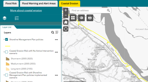
As part of our ongoing SMP refresh work, we improved how we present Shoreline Management Plans on our online maps with greater detail added to the information and content, plus improved links to source material. The additional Policy Rationale, Policy Sub-Categories and links to source Policy documents provide more detail on the proposed policies and hopefully clarify the local intent and management approach going forward.
Figure 1: Screenshot from our webpage showing how we present our Shoreline Management Plans
Climate change allowances
We have completed a project to assess changes in peak river flows and extreme rainfall events due to new climate change data. This work is based on the most up to date predictions of change and will help us to better understand the impacts of increased flows and rainfall on flood risk across Wales. The project outputs have shown an overall increase in both peak river flows and rainfall uplifts of around 10% on current values. We have presented the findings of the project to the Welsh Government and made recommendations on revisions to their climate change guidance. Once agreed, we will work with them to update this guidance for public use and consider what changes are needed for development planning purposes and our Flood Map products.
Local modelling improvements
We have progressed a number of local modelling improvements over the past year. These include projects to improve modelling at the following locations: South Tremadog Bay Tidal Risk, Llandinam, Bala and Meifod.
Management of flood risk assets
This work area includes all activities in relation to the management of our flood risk assets. This includes the construction of new flood alleviation schemes, maintenance of existing structures, understanding their condition, management of asset data and the planning for future work requirements. Its purpose is to ensure the effective and efficient management of our flood risk assets, seek opportunities to reduce flood risk through construction of new assets and ensure our assets are ready and able to perform as expected in times of flooding.
New assets
During 2023/24, we have sustained and reduced the level of flood risk to 1,047 properties which helps to support the Welsh Government Programme for Government ambition of funding additional flood protection for more than 45,000 homes. We have increased protection to 223 properties through completing a significant new Capital scheme at Ammanford (Carmarthenshire) and have sustained the standard of protection to 824 properties through Capital maintenance projects.
Investing in our existing flood risk assets is vital in order to maintain the standard of protection they currently give to the communities which benefit from them. The investment is typically needed to extend or achieve the asset design life and typically involves significant repairs and refurbishment of existing structures.
Alongside the completion of Ammanford, we have made significant progress on several major schemes that were at various stages of development during 2023/24. These schemes will form the majority of our future years capital expenditure and include locations across Wales such as Stephenson Street (Newport), Pwllheli and Porthmadog (Gwynedd), Cardigan (Ceredigion), River Ritec, Tenby (Pembrokeshire) and a Taff Catchment Strategic Flood Management Plan (Merthyr, Rhondda Cynon Taff and Cardiff). In the long term, these are expected to benefit over 3,000 properties when they are completed.
Case study – Flood alleviation scheme at Ammanford, Carmarthen
The construction of new flood defences as part of our new flood scheme in the town of Ammanford, Carmarthenshire, have been completed, reducing the flood risk to 385 properties. A combination of measures have been used to manage the risk of flooding in Ammanford including embankments and walls throughout the town. These are designed to contain floods up to a 1% annual chance of occurrence, including an allowance for climate change. The scheme also involved landscape planting within existing open space, including Bonllwyn Green off Old Road and ground lowering. In addition fish passage improvements have been made to the Tir-y-Dail Weir. We will also be installing Property Level Protection (PLP) measures to houses on Aberlash Road later in 2024.
Figure 2: Photo showing one of the new flood floods constructed in Ammanford as part of the Ammanford flood alleviation scheme.

Asset management
We undertake routine inspection and maintenance programmes to ensure our flood risk assets are fit for purpose. We maintain over 3,900 flood risk management assets which includes approx. 455km length of raised defences throughout Wales.
At the end of the financial year 2023/24, 15,725 routine asset inspections have been completed on assets that we inspect. Our inspections found that 97.18% of our flood assets in high flood risk systems were found to be at or above their required condition to effectively perform their function. This falls just short of our corporate Key Performance Indicator target of 98%. This is a rolling target, reflecting that some assets will inevitably not be at target condition. Assets not at target condition are scheduled for repair or improvement work.
Alongside our routine maintenance programme, we have a number of projects ongoing to help improve asset management within NRW and other Risk Management Authorities, and these are described below.
Flood Risk Asset Management System
We have undertaken a Flood Risk Asset Management System (FRAMS) project to improve the management of our flood risk assets. This will enable us to establish, define and implement an asset management system for FRM assets to deliver best practice asset management. This year we completed work on the FRAMS policy document and have started work on the Strategic Asset Management Plan (SAMP). Once complete, this will allow us to start on the next step of creating Asset Management Plans and implementing them. FRAMS will play a key part in improving the efficiency of how we manage our FRM assets. This will bring multiple benefits to the whole of Wales and add future proofing to our FRM assets, which is key in the face of climate change.
Risk based revenue allocation model (RBRAM)
We have developed a new Risk Based Revenue Allocation Model (RBRAM) utilising our asset management database (AMX), which will enable us to prioritise routine asset maintenance and allocate funding in a more efficient and effective way. Throughout this year we have improved the guidance, standards and specifications in relation to this work and carried out a significant amount of data improvements. This will enable us to ensure our maintenance is prioritised on a risk basis, ensuring we deliver the best value for money through our works whilst also ensuring that maintenance obligations are met. Now the model has been developed and the system functionality tested, it will be used to allocate maintenance funding for 2024/25, although an ongoing programme of further enhancements is planned.
Asset management internal guidance refresh
We have undertaken work to improve many of our internal guidance and procedure documents to ensure that we are following the most up to date processes as we undertake our asset management work. Some of the topics covered include:
- Sediment management
- Wellbeing, Health and Safety requirements
- Permissive powers
- Data improvements for the FRM Asset System
- Flood and Coastal Erosion Risk Management asset management lifecycle.
Asset management - Grass cutting policy
As an organisation, we have instigated a blanket restriction on grass cutting activities across the organisation throughout the month of May for 2024 in line with environmental initiatives such as Plantlife.org.uk ‘No Mow May’. As cutting the grass of our FRM assets is an important maintenance activity to ensure flood defence assets remain in serviceable condition, we have worked this year to develop and implement guidance so we know that we are not causing any detriment to flood risk by taking this approach. This guidance introduces a risk-based approach to where we may apply exception to the rule that will be implemented ahead of ‘No Mow May’ 2024.
Managing public safety in Natural Resources Wales
We own, manage or lease a large range of assets, which vary in size including recreation and flood risk asset sites. We have a legal ‘general duty of care’ to members of the public who interact with our assets as well as moral duty not to cause them harm. We have developed guidance which sets out how we will comply with our legal obligations, particularly providing guidance on when a Public Safety Risk Assessment (PSRA) is required and how to carry it out which is aimed at protecting members of the public who use or interact with our assets to keep them safe.
Reservoirs
There are over 400 large raised reservoirs registered in Wales with a capacity of 10,000 cubic metres of water, or more, held above natural ground level and stored behind a dam, embankment or other structure. The failure of these structures can cause flooding, damage, pollution, loss of utility and can pose a risk to life.
We are the enforcement authority for the safety of large raised reservoirs in Wales. We have a duty to ensure that those who own, manage or operate them observe and comply with the Reservoirs Act 1975 to protect people and property from an uncontrolled release of water. This law sets the minimum standards to ensure the safety of reservoirs, predominantly to ensure reservoir undertakers appoint and act on the advice of specialist qualified civil engineers.
We also manage a portfolio of reservoirs for flood risk and conservation purposes and manage reservoirs in the Welsh Government Woodland Estate on behalf of the Welsh Ministers. Our key activities in these two roles are described in this section.
Reservoir regulatory role
As of 31 March 2024, there were 402 registered large raised reservoirs in Wales. We have a duty to designate a reservoir as a high-risk reservoir if we think human life could be endangered in the event of a failure of the dam. The principal source of evidence for this is through the production of reservoir flood maps which show the consequences of flooding if a dam were to fail.
Table 7 below shows the designation status of reservoirs in Wales as of 31 March 2024. There is no such designation as ‘low risk’. A reservoir which is not designated as a high-risk reservoir remains a large raised reservoir. The designation status determines the level of supervision and inspection by engineers.
Table 7: Table showing the risk designation status of reservoirs in Wales
| Designation status | No. reservoirs |
|---|---|
| High-Risk Reservoirs | 269 |
| Not High-Risk Reservoirs | 76 |
| Designation undetermined | 57 |
Orphan reservoirs
Orphan reservoirs are reservoirs where the undertaker (owner) cannot be determined. In such circumstances, we can step in to undertake safety work, in the interests of public safety. We only do this as a matter of last resort after extensive attempts to identify responsible parties, and the safety risks mean intervention is, in our opinion, needed.
We are currently using our reserve powers under the Reservoir Act 1975 to undertake works at two orphan reservoirs in Wales. Reservoir hazard mapping at these two reservoirs has provided the evidence to confirm their designation as high-risk reservoirs, where a failure could endanger life downstream. We will continue to monitor the safety of these reservoirs through 2024.
Reservoir incidents
We recorded incidents at five reservoirs during 2023/24. One incident occurred on a reservoir that is not designated and four incidents were recorded at designated high-risk reservoirs, which needed the owners to take precautionary action. None required us to step in with emergency powers or to assist.
Reservoir undertakers are responsible for responding to incidents under the guidance of their engineer, and to provide reports to us about the cause and lessons learned.
Developing regulation
We have been working with Welsh Government, DEFRA, the Environment Agency and the other UK regulators in a programme to assess how the law, guidance and practice which supports reservoir safety can be improved.
Management of NRW’s reservoirs
We manage 37 large raised reservoirs, shown in Table 8 below. Thirteen of our reservoirs are constructed primarily for flood risk management purposes, the remainder are managed according to local conservation, heritage and amenity value.
All our reservoirs are inspected and supervised by qualified civil engineers, and we maintain a programme of works to address the recommendations they make. We continue to train ‘reservoir keepers’ to fulfil our maintenance, monitoring and record keeping duties.
Table 8 showing the reservoirs that we managed
| General purpose | Number of reservoirs |
|---|---|
| Flood risk management | 13 |
| NRW conservation sites | 8 |
| Welsh Government Woodland Estate | 16 |
Reservoir improvements
Reservoir safety measures that were recommended and undertaken at Llyn Tegid, Crafnant Loop, Tynymynydd, Llyn Barcud (Bwlch Nant-yr-Arian), Hendre Ddu, Llyn Llywelyn and Pen-y-Gwaith were certified complete during the year. Eight reservoirs currently have recommendations for further safety measures and a programme of works is in place to address these.
Advising planners, permitting and enforcement
This work area relates to all discretionary and statutory advice in regard to flood risk and our role as a consultee within the planning process. The aim is to provide effective advice to influence and control development in flood risk areas, preventing more people and properties becoming exposed to increased flood risk. It also includes our permitting regimes. Combined, these roles seek to control development in flood risk areas and flood risk activities in or around main rivers. We also undertake enforcement where flood risk activities may cause or exacerbate flood risk.
Development planning advice
We are a statutory consultee on flood risk for all development proposals in Flood Zone C2 (areas at risk of 1 in 1000 flood event and without defences) and for highly vulnerable and emergency services development in Flood Zone C1 (areas at risk of 1 in 1000 flood event and with flood defences). Over the past year, our advice has helped to prevent inappropriate development being approved in locations where the risk of flooding would be difficult to manage. Where development has been permitted despite the flood risks, we have provided advice on flood resistance and resilience measures that could be incorporated to help reduce the risk both now and in the future.
During 2023/24 we received and responded to over 2300 planning consultations where flood risk was identified by the Local Planning Authority as a potential constraint. We provided a substantive planning response to these statutory consultations, providing technical advice on the flood risks and consequences. Of the consultations received, around 480 proposals were in zone C2.
Updating TAN15
We are continuing to support the Welsh Government as they revise planning policy TAN15: Development, Flooding and Coastal Erosion (TAN15). Further changes were proposed to TAN15 as part of a public consultation held in 2023. The proposed changes have sought to introduce an increased element of flexibility to facilitate regeneration and redevelopment where the risk of flooding is reduced due to the presence of risk management authority managed and maintained flood defences. Areas benefitting from these defences are mapped in the Flood Map for Planning (FMfP) as TAN15 Defended Zones. We have raised concerns with the proposed policy changes, as whilst flood defences reduce the probability of flooding, they do not eliminate the risk entirely. Defences can be overtopped or fail and the consequences of such an event can be significant so we have strongly recommended that revisions to TAN15 seek to ensure future development is resilient to increasing flood risks and coastal erosion in the context of a changing climate.
Flood map for planning – further enhancements
We are continuing to update the Flood Map for Planning with updated local flood models and evidence provided by local authorities on flood risk from ordinary watercourses and surface water. We also include data from successful flood map challenges and are beginning to include wave overtopping data along some stretches of the coastline into the underlying flood extents. This work is ongoing and will continue over the next 5 years. The map is updated every 6 months in May and November.
Regulating flood risk activities
We regulate activities carried out on or near a main river, on or near a flood defence structure, including a sea defence, or within a flood plain, under the Environmental Permitting Regulations 2016. We do this by issuing a Flood Risk Activity Permit (FRAP) to ensure the activity does not cause any increase in flood risk, adversely impact land drainage in the area, or cause environmental damage to the local environment, fisheries, or wildlife. Some flood risk activities can be carried out without a permit but may need to register with us as ‘exempt’ from the need for a bespoke permit.
Over the 2023/24 financial year, we issued 218 Flood Risk Activity Permits across Wales and 50 exemptions were registered.
Enforcement activity
We undertake flood risk enforcement under the Environmental Permitting (England and Wales) Regulations 2016. This work is important to ensure the effective management of flood risk and to support protection of the environment.If our regulatory advice is not sought, or is ignored, when undertaking works on or near main rivers or flood defences the consequences could be serious. In addition to managing flood risk, our enforcement activity ensures we can maintain access to flood/sea defence infrastructure and allow us to undertake important maintenance and improvement works. We can also use enforcement action to rectify unlawful and damaging or potentially damaging work, which may have been carried out in contravention to conditions set out in a flood risk activity permit, or without a required flood risk activity permit. Examples include damage to flood defences and control structures, removing obstructions that impact flow within rivers, potentially increasing flood risks, and works that have caused harm to the environment.
During 2023/24 we registered 38 cases across Wales where enforcement action for unpermitted flood risk activities was required. We completed enforcement action on 23 cases during this period.
Case study – unpermitted works, Pontardawe, River Tawe
In June 2023, we were made aware that a block stone wall had been constructed on top of a flood defence asset maintained by us (Figure 3). There had been no application for a Flood Risk Activity Permit (FRAP) to undertake the works so it had been constructed without the required permission. We had concerns about the ongoing maintenance of the flood defence if no action was taken.
Figure 3: Image of unpermitted block stone wall constructed on top of NRW’s flood wall along the River Tawe
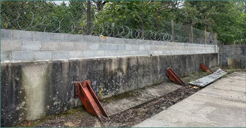
We met with the business owner who explained the block stone wall had been constructed to improve security at the site following a number of break-ins. We advised the business owner that the block stone wall would have to be removed to ensure the integrity of the flood defence could be maintained. The business owner was advised they could rebuild a wall away from the flood defence to help secure the property.
We visited the site again in April 2024 to confirm that the block stone wall had been satisfactorily removed, which it had, so we were able to close the case.
Delivering hydrometry, telemetry and hydrology services
This work area delivers our hydrometry, telemetry and hydrology services which collect, analyse and report data which underpins a range of flood and water management services across NRW. This includes flood risk modelling and mapping, flood risk scheme appraisal and design (standards of protection), reservoir safety, flood forecasting and warning, river regulation and post flood assessments (in terms of the amounts of rainfall, river levels recorded and their severity e.g. historic ranking or return period).
As well as gathering, processing, and archiving this data for NRW, this work area also reports and shares the data with internal and external customers through specific data requests, data transfers and provision of digital services on our website including our live River Levels, Rainfall and Sea Data service.
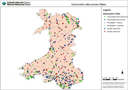
Hydrometric network
The hydrometric network across Wales comprises 253 rain gauge stations, 334 river level or flow monitoring stations and 135 groundwater level monitoring stations. Figure 5 is a map showing the locations of all monitoring stations across our Welsh Hydrometry and Telemetry (H&T) network.
Figure 4: Hydrometric sites across Wales
Hydrometric network review project
During 2023/24, the Hydrometric network review project has focussed on collecting the detailed network and station data required to understand the resilience of our monitoring stations. This has enabled us to make recommendations for network improvements to ensure that the network can continue to deliver the required service, even through periods of the most challenging environmental conditions. This work will continue through 2024/25, with key outputs being made available for consultation and operational deployment as the project progresses.
Telemetry replacement project
We have made significant progress with our £5m investment project to deliver a new Telemetry System. This system will provide near real time river, rainfall and operational plant information which is critical to our response to flooding incidents. Our new telemetry data portal is now live enabling external and internal customers to consume more near real time data via a more effective and resilient platform. We have also made substantial progress with the build of the new system. This work will continue into 2024/25.
UK flood hydrology roadmap
We have continued to work closely with our partners in England, Scotland and Northern Ireland to take forward implementation of the Flood Hydrology Roadmap that was published in March 2022. The roadmap was developed by the UK flood hydrology community and sets out a 25-year vision for flood hydrology, covering all sources of inland flooding and all inland hydrology activities across the UK. This year we have filled a new post within NRW to lead and co-ordinate our input towards delivering the Roadmap and have made contributions to a number of key deliverables including the Flood Hydrology Research Catalogue.
Flood forecasting and issuing warnings
This work area delivers our flood forecasting and flood warning services to the public and professional partners. Its purpose is to provide effective warnings and information to people at risk of flooding enabling them to take direct action to protect life and property in the build up to a flood event.
It includes the detection and forecasting of flooding in real time in the lead up to and during flood incidents, and the issuing of flood warnings to those directly at risk. It also includes the provision of information on the latest situation and warnings in force via our website, Floodline and our live data portal.
Our teams also ensure that data, systems, operational procedures, training of duty staff and management of duty rotas are all in place - and tested and improved – such that they are ready and fully effective in flood events. The services are delivered by a number of specialist duty officer rotas using staff from our teams. Our duty officers are on standby duty 24/7 365 days per year ready to respond to potential and actual flooding at any time of day or night.
Flood forecasting and warning over the 2023/24 financial year
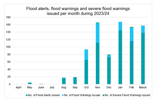
Elevated flood risk is highlighted through the Flood Guidance Statement which provides a daily flood risk forecast for 5 days to Government and professional partners to assist with strategic, tactical, and operational planning decisions around developing flood risk. The information is also shared with the public through our website. From April 2023 to March 2024, there were 139 days of elevated flood risk (minor forecast impacts and above) and within those, 20 days of heightened flood risk (significant forecast impacts and above). Section 1 of this report describes the main flood events during the year that led to elevated flood risk and associated impacts.
In total, we issued 760 flood alerts, 196 flood warnings and three severe flood warnings during 2023/24 in response to the risk of flooding. There were 1,106 calls made to Floodline agents and 1,613,067 visits to our flood warnings and alerts webpage. October, December and January were the months with the biggest number of visits with nearly 800,000 total visits received during these months.
Figure 5: Number of flood warnings and alerts issued during 2023/24
Improvements to the flood forecasting service
We have worked this year to develop new and improve existing flood forecasting models for both river and the sea flood risk areas. We developed and made operational, two new flood forecasting models for the Ely catchment in Cardiff and the Neath catchment. We have also improved the models for the Alyn, Towy, Usk, Loughor and Tawe catchments.
In total across Wales, we provide flood forecasts for 89 sea flooding locations and 112 river flooding locations. These locations are shown in the map in figure 6.
Figure 6: Map of Wales showing the areas covered by our flood forecasting models and locations where we our models are able to provide flood forecasts.

Flood warning system renewal project
The Flood Warning System Renewal Project has made significant progress this year, with delivery of the new system expected in Summer 2024. Issuing flood warnings are critical for us to fulfil our statutory obligation to warn others of the location, timing, and magnitude of flooding from rivers and the sea in Wales. This project will enable us to provide our own independent flood warning service for the people of Wales.
As part of the work undertaken on the project this year, we have put in place the system so that Welsh Language users of Floodline are able to come through directly to us to converse in Welsh. We have also developed a new tool that will make the process of issuing flood alerts and flood warnings much simpler and more efficient for our duty officers as well as improving the message content for those at risk of flooding.
Community engagement and resilience
This work area delivers our community engagement and resilience services to communities at risk of flooding across Wales. It includes provision of information and advice to those at risk of flooding on the practical steps they can take to be better prepared before, during and after flooding. We provide this advice digitally via our website and directly with communities, including providing flood plan templates for them to use and facilitating volunteer network events to share knowledge, experiences, and best practice.
Community flood plans
Community flood plans are volunteer and community led. As of April 2023, we help maintain 71 community flood plans currently in place across Wales to ensure they are fit for purpose and service the communities that own and use them. We continue to enable those who have an interest in their local flood risk or creating a flood plan by sharing resources online and in hard copy where required, and ensuring that they are invited to events arranged by the team and signposted to other organisations that can offer support.
Flood volunteer network events
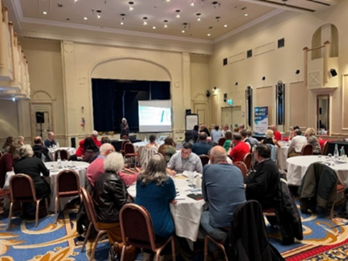
We held 3 Community Flood Volunteer network events in Cardiff, Aberystwyth and Llandudno this year which provided an opportunity to connect with public and partners face to face. We developed a fictional flood scenario, which unfolded over the course of a few days, and seated people from different communities and organisations together to work through the scenario. In total, 23 communities were represented by 39 community members along with 65 professional partners.
Figure 7: Community Flood Volunteer network event at the Angel Hotel, Cardiff, 28 September 2023
Flooding Matters Newsletter
This publication began as a way to keep in touch with the Community Flood Volunteer Network during the pandemic and continues to grow in popularity. From 791 subscribers to the initial newsletter in June 2020, our subscribers have now grown to over 4,700 with the most recent issue. The digital newsletter provides links to more information and gives readers the chance to access the articles that are most interesting to them.
Publications
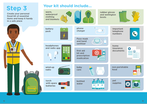
We have been working to update the advice we give in our hard copy booklet ‘What to do before, during and after a flood’. We have taken feedback from customers and staff to improve a number of the sections, including signposting to mental and physical health advice and information about Flood Re’s “Build Back Better” scheme. This will be an engaging and helpful guide to help people prepare for and respond to flooding.
Figure 8: Example image from our ‘What to do before, during and after a flood’ booklet
Flood Knowledgebase
We now have our Welsh language Floodline calls answered in-house so to ensure that customers receive a consistent service in both languages, we have made our flood knowledge database up to date and fully bilingual. We continue to update any major changes to advice when notified by our subject matter experts.
Sustainable flood risk management in the face of coastal change
Coastal communities in Wales face challenges from the existing risk of flooding from the sea, ongoing physical changes and the pressures that climate change is likely to place on them in the future. We play an important role in managing coastal flood risk assets and also working with partners to plan for future changes and the requirements for adaptation over the long term. Within this context, we continue to deliver our responsibilities in relation to Shoreline Management Plans.
Coastal adaptation planning
We deliver the National Habitat Creation Programme (NHCP) on behalf of Welsh Government which was created to meet statutory requirements to provide compensatory habitat offset for coastal plans and projects, where impact on habitats cannot be avoided. During 2023/24, we continued to investigate and develop opportunities for the delivery of compensatory habitat in the Dyfi Estuary, Porthmadog, Pwllheli, Mwche and Laugharne.
The focus and approach to delivering the strategic requirements of the NHCP has evolved to be included as part of the wider Coastal Adaptation Programme (CAP) in response to changing flood risk management (FRM) priorities, UK legislation, and Welsh Government policy on compensatory measures.
A number of vulnerable areas around Wales’s coastline are currently under review for their sustainable flood risk management, potential adaptation and where relevant creation of compensatory habitat. The projects typically involve prioritised sites that are evaluated and subjected to full public consultation to develop the preferred way forward for sustainable flood risk management. This includes the undertaking any further work required to develop our understanding and evidence in relation to flood risk both now and in the future to better inform our decision making. This has been part of the focus within the Dyfi Project and will provide a platform for future assessments within vulnerable coastal areas in the future such as Fairbourne.
Strategic planning
We lead on strategic flood policy matters, develop long term plans and ensure FRM delivers programmes of work in effective and efficient ways.
Skills and capacity
We recognised the need for more effort to be placed on skills and capacity building within FRM and created a new role dedicated to this in July 2020. The purpose of this role is to make sure that the FRM team is in the best place it can be for skills and development so we can tackle our future challenges.
During 2023/24, we continued to invest in the FRM skills and development strategy. The main highlights were:
- We delivered a range of FRM technical training courses including funding day release courses at HNC and post grad levels.
- We delivered the first two-day FRM induction course held at Colwyn Bay. The cohort of new starters came from a wide range of North Wales Risk Management Authorities (RMAs).
- We hosted five Higher Education placements to support the development of the next generation of flood risk management practitioners.
- We launched an FRM podcast series which consisted of ten interviews with a range of FRM practitioners. The podcast has been downloaded over a thousand times and it is hoped that the series will help raise interest with students considering a career in FRM.
Long term investment requirements (LTIR)
In January 2024, we published a report looking at the level of investment required in flood defences to manage Wales’ future flood risk from rivers and the sea against the backdrop of a changing climate. The Long Term Investment Requirements (LTIR) report sets out the findings of the LTIR analysis, using the latest information from the Flood Risk Assessment Wales (FRAW) project and the Asset Management eXpert (AMX) flood asset database. An economic tool was used to assess different investment scenarios, the likely costs and benefits of different policy decisions to help inform decision making and budget planning for Flood Risk Management (FRM) in Wales.
Its findings highlight the need for further action in response to our changing climate, the need for adaptation across many communities around Wales and the sustained need for investment in flood risk management over the long term.
Flood risk management plans (FRMP)
We published our updated Flood Risk Management Plan in November 2023. The plan covers all of Wales and sets out the priorities for managing flood risk for the next six years for the areas of flooding for which we have lead responsibilities: flooding from rivers, reservoirs and the sea. The plan is separated into an overarching national section alongside six place focussed sections. The set of planned measures and actions included in the plan will address the overall objective of reducing the risk to people and communities from flooding from main rivers, reservoirs and the sea, and support the delivery of the 14 priorities set out within the plan.
Section 18 report published
We published the latest Section 18 report covering Flood and Coastal Erosion Risk Management from 2020 to 2023. This report is produced as a requirement under Section 18 of the Flood and Water Management Act 2010. It provides an update to Welsh Ministers on progress made in implementing the Welsh Government’s National Strategy for Flood and Coastal Erosion Risk Management published in October 2020.
Memorandum of Understanding (MOU) refresh with Network Rail
We have renewed our Memorandum of Understanding (MOU) agreement with Network Rail which provides a continued commitment to working in partnership. We have already worked with Network Rail on a number of coastal and river schemes to reduce flood risk, protect habitats, manage land, and better plan projects. Through working in a collaborative way, we ensure public funds are used in the most effectual way possible and by renewing our agreement, we ensure that this continues in the coming years.
FRM research and development
We have a strategic Research and Development (R&D) programme aimed at delivering key evidence to inform and improve our operational and policy needs across FRM. To help meet our research and evidence needs, we work in collaboration with the Welsh Government, Environment Agency and Defra on the joint Flood and Coastal Erosion Risk Management (FCERM) Research and Development programme. The programme aims to serve the needs of all flood and coastal operating authorities in Wales and England. Over the last year, the Joint Flood and Coastal Erosion Risk Management R&D Programme has published several key projects in which NRW has been involved including the The Natural Flood Management (NFM) manual. The full list of projects can be found on the FCERM research and development projects site.
Over the last year, we have been working closely with Joint R&D Programme to develop a Joint research plan. This covers eight areas of research interest (ARIs) for the programme and is set to 2028. These are used to concentrate research activity and engagement for the programme. More details can be found here.
The wider programme consists of 57 projects split into 3 theme areas: 1) Policy, Strategy and Investment, 2) Asset Management and 3) Incident Management and Modelling. Our staff are engaged directly with 22 of these projects either as a corresponding member or actively involved at a project board level.
Nature based solutions
Nature-based solutions refers to the use of natural features and processes to tackle socio-environmental issues. Natural flood management (NFM) is considered to be a nature based solution to help address flooding by using or restoring natural processes to reduce the risk of flooding and coastal erosion. NFM can also provide many wider benefits including biodiversity improvement, increasing ecosystem resilience, improving water quality and storing carbon.
A key priority of the Welsh Government National Strategy for Flood and Coastal Erosion Risk Management (FCERM) in Wales is to deliver more natural interventions and catchment approaches to reduce flood risk. Flood risk management authorities in Wales are required to consider the use of NFM when developing options for new flood schemes and maintenance activities. We aim to integrate NFM within flood and coastal risk management activities where feasible and appropriate to reduce the risk and impacts of flooding, adapt to climate change, contribute towards the objective of ecosystem resilience and support the sustainable management of natural resources. We are developing our approach to the implementation of NFM, recognising the need to use all the tools available to manage future climate risks.
Developing our approach to NFM
As an organisation we want to lead by example, delivering our corporate objectives to protect and enhance nature, respond to the climate emergency, and minimise pollution. The implementation of NFM measures has the potential to deliver against these objectives and has an important role in supporting action to address the climate and nature emergency.
NFM is a complementary approach to our other flood risk management activities and will be most effective when delivered as part of a plan or in areas where it is possible to make a measurable difference. These areas are likely to be smaller catchments or in areas where there is more frequent and lower impact flooding. Successful delivery of NFM requires the buy in and involvement of a range of partners, stakeholders, communities, and land managers with actions co-ordinated across a catchment. We are exploring ways of doing this. Below are two examples of where we are working with others in a collaborative way to deliver positive impacts for the environment of Wales, including NFM.
Clwyd catchment case study
We have supported stakeholders to establish a Clwyd Forum aimed at improving the sustainable management of the Clwyd catchment through integrated approaches. The forum provides the opportunity for various stakeholders to address issues in the Clwyd catchment collaboratively and strategically to achieve tangible benefits, at strategic and project levels.
One of the forum's goals is to promote NFM and the implementation of woody debris in the Clwyd catchment. Knowledge sharing between stakeholders has formed an important part of discussions and enabled the forum to successfully support Lead Local Flood Authority applications to the Welsh Government NFM Accelerator Fund. The forum will continue to provide support and guide delivery over the coming years with a committed action plan to delivering priorities such as NFM.
Uwch Conwy project
The Uwch Conwy project is a landscape scale partnership project covering 3% of Wales. The overall aim of this project is to work with farm tenants and other partners to improve land and water management whilst providing benefits to the communities and wildlife that call this part of Eryri home.
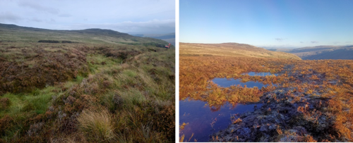
We are working at a catchment scale to restore modified peatlands and river systems, as well as re-creating and re-connecting habitats through woodland and hedgerow planting and meadow creation. This year work has focussed on restoring peatland on the Mignient and y Gylchedd by blocking over 15km of ditches and creating 66 pools to slow the flow of water. Working with tenants and local land owners, we have created 2km of riparian habitat through the creation of buffer strips, and installed over 500m of contour hedgerows to slow overland flow as well creating wildlife corridors, providing shade for stock and improving livestock handling. The work this year has been funded through the Welsh Government Nature and Climate Emergency fund, Nature Networks Fund 2, National Peatland Action Programme as well as funding from NRW and National Trust.
Figure 9: Photos showing peatland restoration above Foel farm, cwm Penmachno, Conwy. The left image shows the peatland before restoration. The image on the right shows the peatland restored. Photo credit Iago Thomas, National Trust Uwch Conwy peatland officer.
Natural Flood Management projects
We are working to promote and support the use of NFM interventions within our work where appropriate. We have successfully bid for funding from the Welsh Government NFM Accelerator programme to take forward two projects which contributes to the Welsh Government Programme for Government measure to deliver nature-based flood management in all major river catchments to expand wetland and woodland habitats.
River Cadoxton, Dinas Powys
We have continued our work with the community of Dinas Powys, reviewing the river Cadoxton channel maintenance regime, developing a business case for river flow gauging and appraising the NFM options in the catchment. Together, these activities cover the whole catchment to inform flood risk management options. We have recruited a dedicated engagement officer for the catchment, to support our NFM project, but also integrating River Restoration options for the Cadoxton and its tributaries.
Dwyran, Anglesey
We have identified opportunities for NFM within the Afon Rhyd y Valley catchment to reduce flood risk in Dwyran, Anglesey. Working closely with the Dwyran Flood Partnership Group, we aim to deliver a range of NFM measures to reduce peak flood flows and provide wider benefits, including improvements to the ecological status of the river.
Natural flood management evidence and research
We continue to work with partners to understand the effectiveness of nature based solutions in reducing flood risk and providing wider ecosystem service benefits.
The update to the ‘Working with Natural Processes Evidence Directory’ which was first published in 2017 through the Joint England and Wales (Flood and Coastal Erosion Risk Management) Research and Development Programme is complete and will be published in summer 2024. This update summarises newly emerged evidence in relation to the effectiveness of a range of different measures at reducing flood risk and the wider ecosystem services they provide. It follows a similar structure to the original Directory, and reflects advances in the science and practice of working with natural processes.
Where our money is spent
We are funded to deliver FRM work directly by Welsh Government in the form of Flood Defence Grant in Aid (FDGiA) funding. This takes the form of revenue funding which supports routine operational and “business as usual” activities and services as well as capital funding which is utilised to deliver project work.
In 2023/24 NRW received a total of £56.6m of Welsh Government FDGiA funding to undertake FRM work, this comprised of £24.5m of revenue funding and £32.1m of capital funding. This funding was fully utilised in this financial year to deliver the FRM outcomes, sustain the services NRW provides and many of the successes outlined in this report.
Capital funding
For financial year 2023/24, our original capital budget was £22m. The programmes performance was heavily dependent on construction progress at Stephenson Street (Newport) and Ammanford. Both projects progressed extremely well throughout the year, did not hit any major issues and therefore were able to accelerate delivery of significant areas of work. This is very rare for projects of this size. Significant Business Transformation projects (Telemetry and the new Flood Warning System) as well as the rest of the programme also progressed very well. This led to us having to negotiate additional in-year funding with WG. We successfully secured an additional £7m in October 2023. Following this, we also agreed to spend further additional capital that WG made available to us, as well as some additional capital reallocated internally. As a result of this additional funding, our final budget for 2023/24 was £32.1m. This funding enabled the delivery of over 110 projects within our Capital Programme, including many of the projects highlighted in this report and many examples of ongoing work which will complete in future years. A breakdown of capital spend by project type is included in figure 10 below:
Figure 10: Chart showing the breakdown of Capital spend by project type

Core Activities include capitalised salary costs (£2.5m), contributions to wider corporate enabling services (£1.1m) and fleet, plant and equipment purchase (£650k). Capital Business Transformation costs relate to FRM specific ICT system development or contributions to system development which benefits FRM services. In 2023/24 this included projects replacing our flood warning system and our telemetry system.
Revenue funding
The 2023/24 revenue settlement of £24.5m supported the significant effort that goes into sustaining and providing the services, advice, tools, and activities NRW undertakes to help manage flood risk in Wales. This funding predominantly supports staff costs, routine maintenance works, various enabling services which support our work and other routine activities. A breakdown of revenue spend by activity is included in figure 11 below.
Figure 11: Chart showing the breakdown of revenue spend by activity
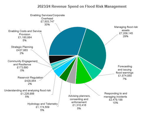
Each of these work areas interact and overlap with each other to deliver key services, therefore there are some areas where teams support wider activities which can misrepresent the scale of effort in some of the above activities as many areas are interdependent on each other to deliver outcomes. For example Hydrometry and Telemetry work heavily supports forecasting and issuing flood warnings.
Enabling Service and Corporate Overheads include FRM’s contribution to the operation of key business services which support the delivery of FRM activities. These include Communications, Procurement, Governance and Leadership, Corporate Planning, Legal Services, People Management, Facilities, Fleet Management and Finance. Service Provision costs are associated with operating and maintaining key systems, tools and services supported by others, for example the Environment Agency.
The revenue budget of £24.5m was fully utilised in 2023/24 and helped support many of the initiatives outlined in this report and ensured that our “business as usual” services continued to be delivered effectively.
Staff numbers
The effort that goes into delivering FRM work within NRW can broadly be grouped into the following work areas and structures:
- National services and policy teams reporting to the Head of Flood and Incident Risk Management within the Evidence, Policy and Permitting Directorate.
- Direct FRM technical services reporting to Flood and Water Management Managers within the Operations Directorate.
- Integrated operational delivery teams reporting to Land and Asset Managers within the Operations Directorate.
- Enabling Services providing central support to all NRW functions are also part funded proportionately by FRM funding to enable the delivery of the services they provide.
As of March 2024, we estimate the FTE staff numbers working directly within the FRM areas identified as per the following table, (this report does not contain data on the number staff working in enabling services as this is too complex to identify specific roles and contributions).
Table 9: Full time equivalent staff posts working directly in FRM as of March 2024 (all posts, including vacant posts)
| Full Time Equivalent Staff Numbers | Organisational Work Area |
|---|---|
| 63.8 | National services and policy teams |
| 143.3 | Direct FRM technical services |
| 172.5 | Integrated operational delivery teams |
| 379.6 | Total estimate of FRM funded FTEs in NRW |
Forward look
Whilst the purpose of this report is to focus on the outcomes and achievements of the 2023/24 financial year, a substantial amount of the work undertaken supports the delivery of projects and outcomes that will deliver in future years.
Listed below are some key highlights of the work we plan to complete or progress in the coming financial year (2024/25).
Flood warning system renewal project
Delivery of the new Flood Warning System Renewal Project is expected in Summer 2024. This will provide an improved system for issuing flood warnings for the people of Wales.
Flood alleviation scheme at Liswerry, Newport
We are undertaking a major new flood alleviation scheme at Liswerry, Newport, that will reduce flood risk to over 800 properties (over 2,000 properties over the long term when climate change is factored in). The scheme is progressing extremely well, with over £13m being spent during 2023/24 which is the most NRW have ever spent on a FRM capital project in a calendar year. This is also by far the most significant FRM scheme undertaken by NRW. If the scheme continues on its current trajectory, construction will be completed by December 2024. The total cost of the scheme is estimated at approximately £25m with the benefits of the project highlighted through the cost of a significant flood affecting the area being estimated at £230m.
Inclusion of wave overtopping within flood risk from the sea datasets
We have commenced a programme of works to incorporate wave overtopping risk into our Flood Risk from the Sea maps for the communities where the risk is greatest. These maps currently only show extreme sea level so by including wave overtopping we will be able to give a more accurate display of flood risk especially for exposed coastal locations. This will begin during May 2024.
Risk based revenue allocation model (RBRAM)
We will continue to establish our new maintenance planning and prioritisation model, this will work towards our aim of making our work truly risk based and ensure that we get the best value for money out of the funding utilised on our routine maintenance work. We will continue to work throughout the financial year to drive improvements in reviewing the completeness of maintenance data on AMX, scheduling maintenance programmes and monitoring the delivery of maintenance activities. Guidance will be developed to help FRM practitioners to achieve these aims.
Flood forecasting rota resilience
There is not enough duty officer resilience on our flood forecasting rota which covers forecasting of flooding for rivers and the sea across the whole of Wales. We have identified a number of new duty officers who will be trained up throughout 2024 before joining the rota in early 2025.
Flood forecasting service improvements
We are developing a programme of work to increase flood forecasting coverage, improve communication of expected flood risk and better understand the uncertainty associated with forecasting flood events. This work will be delivered in phases over the coming years but once complete, will lead to earlier communication with the public and professional partners which will provide a greater understanding of potential flood risk and a better understanding of the likely impacts.
Improving available flood risk information
We are undertaking a project to improve the understanding and transparency of how FRM work is planned and prioritised, including improving understanding of the Communities at Risk Register. This work will take place during 2024/25.
Assets facing coastal change
We are considering what changes are needed in managing our coastal assets, especially where there is a change in Shoreline Management Plan policies. We have considered the scale of management changes required to ensure compliance with the Shoreline Management Plans and the impending epoch change approaching in 2025. We will move on to phase two which involves analysing this information in more detail, determining our future management strategy approaches in these areas and developing the necessary policy and guidance to support the delivery of our adaptation work.
Telemetry replacement project
During 2024/25 we will complete our telemetry replacement project so that the new system and Remote Telemetry Units (RTUs) at over 600 telemetered monitoring sites across Wales can continue to deliver the data we depend on for making critical warning and operational response decisions during flood events.
Other places in Flooding reports, evidence and data
Last updated