
Beddgelert Forest, near Beddgelert
Huge forest in the heart of Eryri (Snowdonia)...

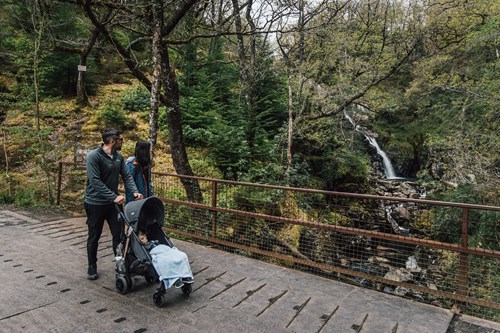
Tyddyn Gwladys is the starting point for a walking trail to the famous waterfalls known as Rhaeadr Mawddach and Pistyll Gain.
This circular trail also goes past the Gwynfynydd goldmine which closed in 1999.
In the car park, there are picnic tables under large trees beside the rolling Mawddach river.
The walking trail is waymarked and starts from the car park.
The trail is nearly all on forest road with one section of very rough private track before you get to the waterfalls and one steep but short climb 20%/1 in 5 after leaving them.
There are no steps or stiles and the trail is suitable for pushchairs and mobility scooters.
On this trail there are two benches, one picnic table and two gates with passing places 80cm wide.
Please stay on the waymarked trails as the old mine workings and buildings may be unsafe and there are unprotected drops into the river gorges.
You can also download an audio trail and listen to the history of the Tyddyn Gwladys Gunpowder Works.
Discover the stories of the people who worked at Tyddyn Gwladys Gunpowder Works and learn about the gunpowder works’ history on our mp3 audio trail.
It has been designed for use on the Waterfalls and Goldmines Trail from the Tyddyn Gwladys car park.
There are numbered posts on the walking trail which tell you when to play each section.
As mobile phone network coverage can be limited in rural areas, we recommend that you download the audio trail before your visit.
You can also download a PDF file of the script.
To download the audio trail go to Audio trails and folk tales.
Coed y Brenin Forest Park offers visitors the total woodland experience within Eryri (Snowdonia) National Park.
There is a range of waymarked trails to cater for all tastes and fitness levels in the forest park. These include world-class mountain bike trails, family walks, running trails, geocaching and orienteering routes.
As well as the trails that start here at Tyddyn Gwladys, the main car parks with facilities for visitors within Coed y Brenin Forest Park are:
Coed y Brenin Forest Park is set in Eryri (Snowdonia) National Park.
Eryri is the largest National Park in Wales and is home to picturesque towns and villages and the highest mountain in Wales.
It is looked after by the Eryri National Park Authority.
For more information about visiting Eryri go to the Eryri National Park Authority website.
Coed y Brenin Forest Park forms part of the National Forest for Wales.
The National Forest will:
It will form a connected ecological network running throughout Wales, bringing social, economic and environmental benefits.
Parts of the network will eventually form a trail running the length and breadth of Wales, so anyone can access it wherever they live.
For more information go to the National Forest for Wales website.
We want you to return home safely after your visit here.
You are responsible for your own safety as well as the safety of any children and animals with you during your visit.
For advice and tips to help you plan your visit here go to Visiting our places safely.
See the top of this webpage for details of any planned closures or other changes to visitor facilities here.
For your safety, always follow instructions from staff and signs including those for trail diversions or closures.
We may divert or close trails whilst we undertake maintenance work or other operations and we may need to close other visitor facilities temporarily.
In extreme weather, we may close facilities at short notice due to the risk of injury to visitors and staff.
Tyddyn Gwladys car park is just off the A470, near the village of Ganllwyd.
It is in the county of Gwynedd.
The OS grid reference is SH 734 262.
Take the A470 from Dolgellau towards Betws-y-coed.
Just before leaving the village of Ganllwyd turn right onto a minor road and go over a stone bridge.
Follow the signs to Tyddyn Gwladys for 1¼ miles and the car park is on the right (you will pass the small car park for Pont Cae’n y Coed on the way).
The nearest train stations are in Barmouth (Cambrian Coast line) and Blaenau Ffestiniog (Blaenau Ffestiniog-Llandudno line).
For details of public transport visit www.traveline.cymru
Car parking is free of charge.
Overnight parking is not permitted.
Coed y Brenin Forest Park Visitor Centre
Tel: 01341 440747


